The Vamsadhara River, a vital waterway in eastern India, derives its name from the words “bansa” (bamboo) and “dhara” (water flow). This name reflects the river’s origins in bamboo-filled forests and its gentle flow through beautiful landscapes. In Oriya, the river is called “Bansadhara,” while in Telugu, it’s known as “Vamsadhara.”

Geographic Features of the Vamsadhara River
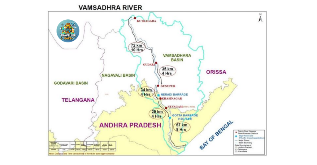
- Location: The Vamsadhara River flows between two prominent rivers—Godavari and Mahanadi—on India’s east coast.
- States Covered: It travels through Odisha and Andhra Pradesh, supporting many communities along the way.
- Basin Area: It covers 8,015 square kilometers in Odisha and 2,815 square kilometers in Andhra Pradesh.
- Rainfall: The basin receives around 1,400 millimeters of rainfall annually.
- Origin: The river originates at the border of Kalyansinghpur in Rayagada district and Thuamul Rampur in Kalahandi district, Odisha.
- Length: Stretching 254 kilometers, it eventually empties into the Bay of Bengal near Kalingapatnam, Andhra Pradesh.
- Terrain: Hilly landscapes dominate Rayagada district in Odisha, where vibrant tribal communities reside.
- Water Resources: The river provides an estimated 115 thousand million cubic feet of water annually for use in both states.
Major Tributary: Mahendratanaya River
The Mahendratanaya River is a significant tributary of the Vamsadhara, contributing greatly to its flow. Originating in Gajapati district, Odisha, this river flows through scenic hilly areas before joining the Vamsadhara in Andhra Pradesh. Its waters support agriculture, enhancing the livelihoods of many farmers along its path. Construction of a barrage at Regulapadu is underway to divert water for irrigation purposes.

River Water Dispute
A long-standing interstate water-sharing dispute exists between Odisha and Andhra Pradesh over the Vamsadhara River’s resources. The disagreement stems from each state’s desire to harness the river’s waters for agriculture and development.
Key Agreements and Developments:
- 1962 Agreement: The two states agreed to share the river’s water equally, in a 50:50 ratio.
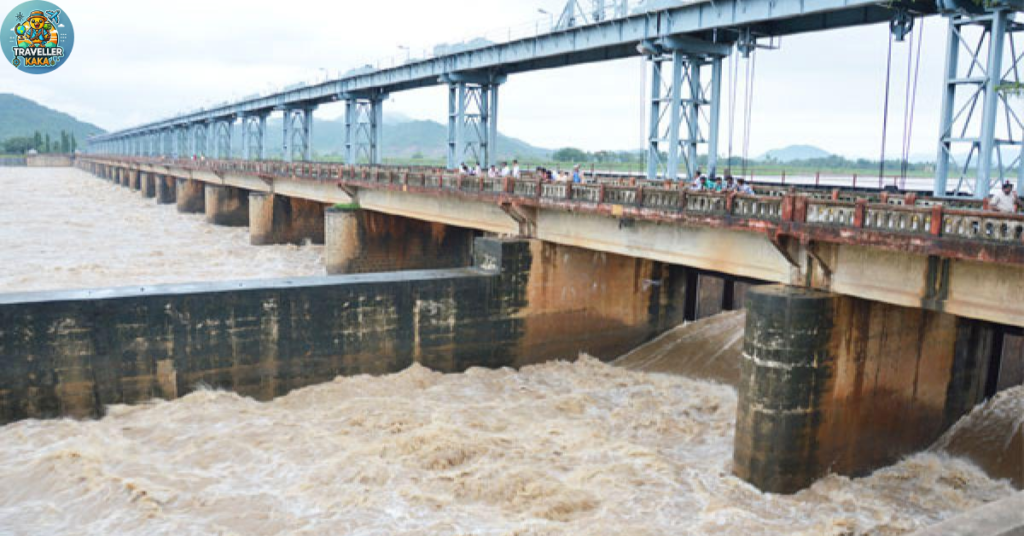
- Andhra Pradesh Projects: Andhra Pradesh initiated projects such as the Gotta Barrage and Neredi Barrage to utilize its share of water.
- Odisha’s Move: Odisha diverted water to the Rushikulya River Basin through the Harabhangi dam, which escalated tensions between the states.
Vamsadhara River Tribunal:
In response to the ongoing dispute, the Vamsadhara River Water Disputes Tribunal was established, led by Justice Mukundakam Sharma. In 2017, the tribunal permitted Andhra Pradesh to proceed with the construction of the Neredi Barrage. Both states must adhere to the 50:50 water-sharing ratio established in the 1962 agreement.
In 2021, the tribunal issued its final ruling, upholding the previous decision, and emphasized the importance of cooperation between the states to manage water resources sustainably.
Nearby Attractions to Vamsadhara River
- Kalingapatnam Beach
Located at the confluence of the Vamsadhara River and the Bay of Bengal, this scenic beach is known for its peaceful surroundings and picturesque views. - Gotta Barrage
A key irrigation project on the Vamsadhara River in Andhra Pradesh, Gotta Barrage offers a glimpse into the region’s water management and agricultural development. - Mahendragiri Hills
The hills in Gajapati district of Odisha offer breathtaking views and hold great mythological significance. They offer trekking opportunities and serene natural beauty. - Srikurmam Temple
Located near Srikakulam, this ancient temple dedicated to Lord Vishnu is renowned for its unique architecture and religious significance. - Kaviti Beach
A lesser-known but beautiful beach near Kalingapatnam, Kaviti Beach is ideal for a peaceful retreat and enjoying coastal beauty.
Components of the Project:
- Left Main Canal (LMC): This canal irrigates 148,000 acres of farmland, significantly boosting agricultural productivity.
- Right Main Canal (RMC): Covering 62,280 acres, this canal is fed by the Gotta Reservoir, which ensures a steady supply of water for irrigation.
Conclusion
The Vamsadhara River is not only a lifeline for the communities in Odisha and Andhra Pradesh but also an essential resource for agriculture. Through sustainable water management and cooperative agreements, the river’s flow can continue to nurture the land and the people it supports. The Vamsadhara Project has transformed the agricultural landscape of Uttarandhra, ensuring a brighter future for its farmers and the environment.
FAQS
ANS) The Vamsadhara River flows through the states of Odisha and Andhra Pradesh.
ANS) The river flows for approximately 254 kilometers before joining the Bay of Bengal.
ANS) The Mahendratanaya River is the major tributary, which contributes to the flow of Vamsadhara.
ANS) Key projects include the Gotta Barrage and Neredi Barrage in Andhra Pradesh, aimed at using the river’s water for irrigation.
ANS) The Vamsadhara Project aims to provide irrigation facilities to the Uttarandhra region, boosting agricultural productivity.


